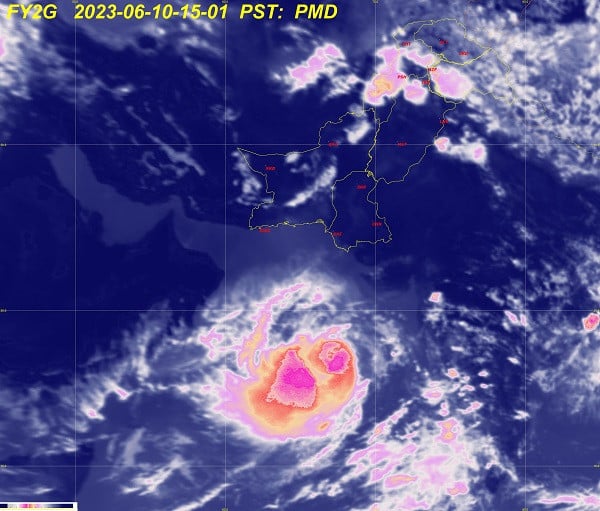
Title: Ferocious Biparjoy around 900km south of Karachi
Share:
Linkedin
Whatsapp
Facebook
 Description:
Cyclone Biparjoy was estimated to be roughly 900 kilometres due south of Karachi on Saturday as the storm - categorised as very severe - continued on a north/north-eastward track.
"The Very Severe Cyclonic Storm (VSCS) “ BIPARJOY” over east-central Arabian Sea maintaining its intensity further tracked north-northeastward during past 12 hours and now lies near Latitude 16.7°N & Longitude 66.4°E at a distance of about 910km south of Karachi, 890km south of Thatta & 990km southeast of Ormara."
While authorities are unsure of the cyclone's track in the coming days, the coastal areas of Sindh and Balochistan have been put on alert.
By Friday night, Biparjoy was located around 1,120km away from Karachi – roughly the same distance between Karachi and Lahore. The PMD said that its wind speed around the system reached 160km/h with 150km/h at its centre.
Read: Sindh, Balochistan on alert as ferocious cyclone nears
In its latest update issued today, the Pakistan Meteorological Department (PMD) said sustained surface winds are 120-130km/h and gusting up to 150km/h around the system's core.
"The favorable environmental conditions (sea surface temperature of 30-32°C, low vertical wind shear & upper-level divergence) are in support to intensify the system further," said the PMD
The weather service cautioned that due to a shift in upper-level steering winds, there is uncertainty in global forecast models where some are predicting landfall around the Markan-north Oman coast while others indicate its path towards the Sindh-Indian Gujarat coastline.
"Given this uncertainty, the system is predicted to keep tracking further north/northeastward during next 18-24 hours and then slightly recurve to North-northwest."
The PMD advisory further warned that due to the north-northeast track of Biparjoy, "rain-thunderstorm with some heavy falls and squally winds are expected in the Sindh-Makran coast from June 13 evening/night onwards".
It also advised fishermen not to venture out at sea from Sunday (June 11) as sea conditions are "very high/phenomenal around the system centre with maximum wave height 25-28 feet".
NEOC Update: Very Severe Cyclonic Storm (VSCS) #BIPARJOY status.
Development path based on intl weather models is for proactive measures against likely impacts. It's an evolving situation& impact will only be certain with further development of sys.
Source: Zoom Earth pic.twitter.com/BUzpxyRxJU
— NDMA PAKISTAN (@ndmapk) June 10, 2023
The National Disaster Management Authority (NDMA) also cautioned that the situation is evolving with the "further development of the system".
Published Date: 10-Jun-2023
Share:
Linkedin
Whatsapp
Facebook
